
Montenegro · Lake Skadar · Practical Map Guide
Rijeka Crnojevića
Map Guide
A practical map-style guide to Rijeka Crnojevića — how the village is laid out, where to find the old bridge, riverfront, parking, boat departures, restaurants, scenic roads and Pavlova Strana viewpoint.
The Short Answer
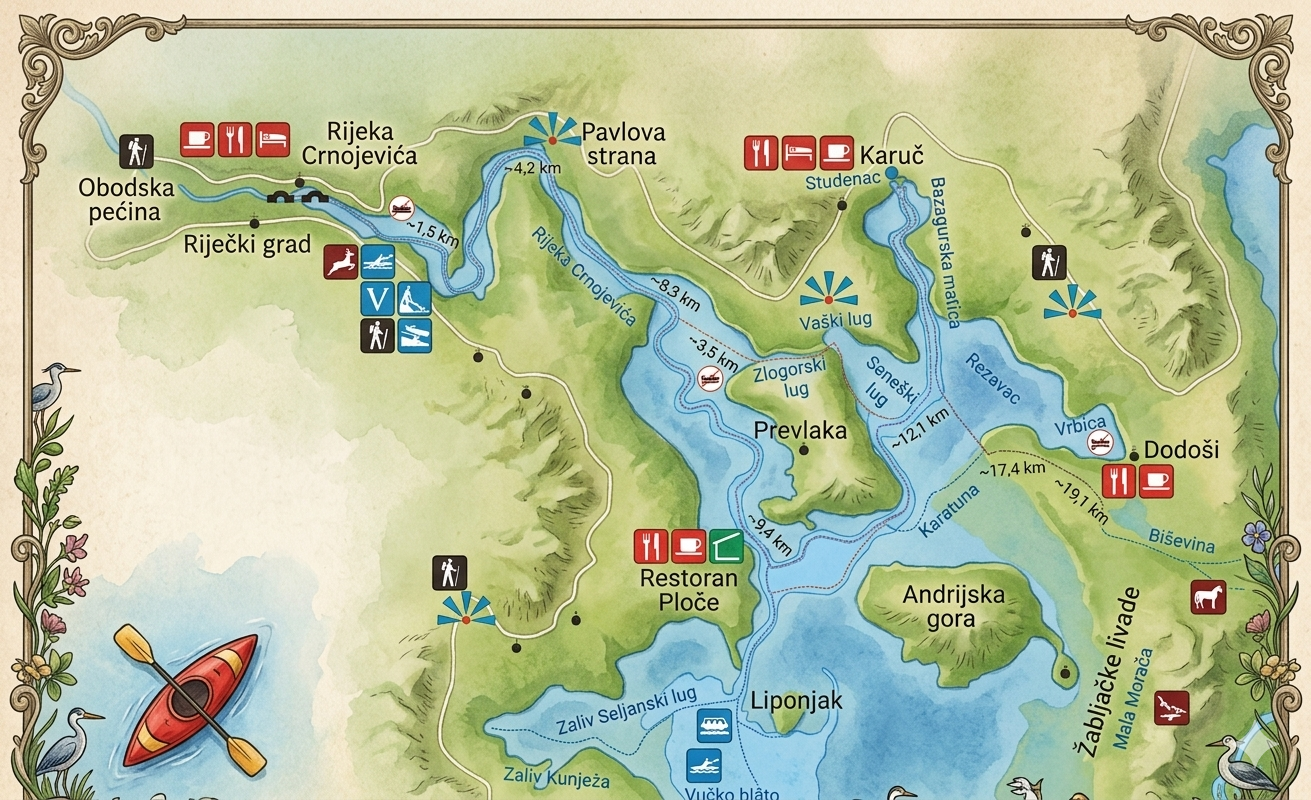
Rijeka Crnojevića is easy to understand on a map: one small village, one riverfront, one old bridge, and one scenic viewpoint above it all.
You do not need a complicated map to visit Rijeka Crnojevića well. What matters is understanding the relationship between the old bridge, riverfront, parking area, boat departures, restaurants, scenic road and Pavlova Strana viewpoint.
Rijeka Crnojevića is a compact village, but it can feel confusing before you arrive because the experience is spread across several different layers: the riverside village itself, the approach roads, the famous Pavlova Strana viewpoint above the river, and the wider Lake Skadar landscape beyond the bends.
The village centre is simple once you are there. Park carefully, walk toward the old bridge, follow the riverfront, choose whether to eat or take a boat tour, then decide if you want to continue toward Pavlova Strana or another Lake Skadar viewpoint.
This map guide helps you visualise the area before arriving. It is not a technical GPS map, but a practical orientation guide: what is close to what, what should be visited on foot, what requires a car, and how to connect Rijeka Crnojevića with Pavlova Strana, boat tours and Lake Skadar itineraries.
I. Main Map Points
The places to locate first on your Rijeka Crnojevića map.
01 · Old Bridge
The Main Landmark
The old bridge is the easiest point of orientation in Rijeka Crnojevića. Once you have found it, the rest of the village becomes simple: the riverfront, restaurants and boat departures are all part of the same compact area.
Use the bridge as your starting point, especially if this is your first visit. It gives you a clear visual anchor and a natural place to begin walking.
02 · Riverfront
The Heart of the Visit
The riverfront is where Rijeka Crnojevića slows down. This is where you find the waterside atmosphere, small boats, restaurant terraces and the quiet rhythm that makes the village worth visiting.
On a map, it may look like a small stretch. In reality, this is where you will spend most of your time if you are having lunch, taking photos or waiting for a boat tour.
03 · Parking Area
Think Practical, Not Perfect
Parking in Rijeka Crnojevića is less about finding one official point and more about arriving respectfully in a small village. Park where you are not blocking local access, then continue on foot.
The village is compact enough that a short walk is usually easier than trying to get closer to the bridge by car.
04 · Boat Departures
Usually Close to the Riverfront
If you are taking a boat tour from Rijeka Crnojevića, orient yourself around the riverfront rather than a separate marina area. The village is small, and boat activity is closely linked to the riverside centre.
Arrive early enough to park, walk to the meeting point and confirm details without rushing through the village.
05 · Scenic Road
The Road Frames the Village
On a map, Rijeka Crnojevića is not just a dot beside water. It is connected to a scenic road system that gives the village much of its atmosphere. The drive in and out is part of the experience.
Use your map to understand the route before you arrive, especially if you plan to continue to Pavlova Strana or other Lake Skadar viewpoints.
06 · Pavlova Strana
Above the Village, Not Inside It
Pavlova Strana is often associated with Rijeka Crnojevića, but it is not in the village centre. It is a viewpoint above the river, reached by road, and should be treated as a separate stop on your map.
The best map logic is simple: village first for the bridge and riverfront, viewpoint separately for the famous river bend from above.
Featured · Map Logic
Think in three layers:
the village, the road and the viewpoint.
The easiest way to understand Rijeka Crnojevića on a map is not to look for one single point. The experience has three layers. The first is the village itself: old bridge, riverfront, restaurants, boats and parking. This layer is best explored on foot.
The second layer is the road: the way you arrive, the bends, the approach from Cetinje, Podgorica, Virpazar or the coast, and the scenic rhythm around Lake Skadar. This layer is best planned before you drive.
The third layer is Pavlova Strana, the viewpoint above the river. It completes the map because it lets you see the landscape from above after you have already experienced it from water level.
II. How to Use the Map
Plan your visit in the right order.
i.
First, choose your route
Before looking at the village centre, understand how you will arrive: from Podgorica, Cetinje, Virpazar, Budva, Kotor or the coast.
Use: How to Get There.
ii.
Then, park and walk
Once in the village, stop trying to optimise every metre. Park respectfully and walk to the old bridge and riverfront.
Use: Parking Guide.
iii.
Add boat or lunch
From the riverfront, decide whether the visit becomes a quick stop, a lunch break or a boat tour experience.
Use: Boat Tours Guide.
iv.
Finish above the river
Use Pavlova Strana as the final map layer: the place where the river you just visited becomes a landscape.
Use: Pavlova Strana Guide.
Practical Map Advice
Download offline maps before you drive
Even if you know where you are going, it is smart to prepare your route before leaving the main roads. The area around Rijeka Crnojevića includes scenic rural roads, bends, small junctions and viewpoints that are easier to understand when your map is already loaded.
Do not rely only on real-time signal or last-minute decisions. Save Rijeka Crnojevića, Pavlova Strana, your parking area and your return route before you start. This is especially useful if you are combining the village with a scenic drive, boat tour or wider Lake Skadar itinerary.
- Save: Rijeka Crnojevića village centre.
- Save: Pavlova Strana viewpoint.
- Save: your chosen route back to your base.
- Check: whether your itinerary uses narrow scenic roads or simpler main-road access.
III. Map Mistakes
Avoid reading the map too literally.
Assuming distance equals ease
A place can look close on a map but still require slow rural driving, bends or careful stopping. Allow more time than the map suggests.
Treating Pavlova Strana as central village
Pavlova Strana is linked to Rijeka Crnojevića, but it is a separate road viewpoint. Plan it as an add-on, not as part of the walkable village centre.
Skipping offline preparation
Save your route before the trip. Offline maps are useful around rural roads, viewpoints and places where signal may be less reliable.
Beyond the Map
What to read next.
Once you understand the map, it becomes easier to plan the visit. Use these guides to move from orientation to action: choose the right road, park well, visit the bridge, take a boat tour and finish with the best viewpoint above the river.
- How to Get to Rijeka Crnojevića — choose the right route and transport option
- Parking in Rijeka Crnojevića — arrive without stress
- Rijeka Crnojevića Old Bridge — the easiest landmark to locate first
- Lake Skadar Boat Tours — understand the river route from the village
- Pavlova Strana Viewpoint — see the wider map from above
FAQ
Frequently asked questions.
Where is Rijeka Crnojevića on the map?
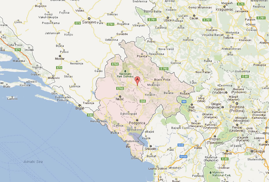
Rijeka Crnojevića is in the Lake Skadar area of Montenegro, inland from the coast and connected by scenic roads to places such as Cetinje, Podgorica, Virpazar and the wider national park region.
Is Rijeka Crnojevića easy to navigate?
Yes. The village itself is small and easy to understand once you arrive. The old bridge, riverfront, restaurants and boat departure area are close together and best explored on foot.
Where is Pavlova Strana compared with Rijeka Crnojevića?
Pavlova Strana is not in the walkable village centre. It is a viewpoint above the river, reached by road, and should be planned as a separate scenic stop before or after visiting the village.
Do you need a map for Rijeka Crnojevića?
You do not need a complicated map for the village itself, but it is useful to save offline maps for the approach roads, Pavlova Strana, parking and your return route.
Can you walk around Rijeka Crnojevića?
Yes. Walking is the best way to explore the village centre. Park respectfully, then walk to the old bridge, riverfront, restaurants and boat area.
Where should you go first?
Start with the old bridge. It is the easiest landmark to find and gives you a clear sense of the village layout before you continue to the riverfront, restaurants or boats.
Should you visit Pavlova Strana before or after the village?
Both work. Visiting the village first helps you understand the river at ground level, then Pavlova Strana shows the same landscape from above. For photography, late afternoon can be especially rewarding at the viewpoint.
Can you use Rijeka Crnojevića as a base for Lake Skadar?
Yes, especially if you want a quieter, more atmospheric side of Lake Skadar. It works well for scenic roads, boat tours, Pavlova Strana and slow day trips around the river landscape.
Orient Yourself
Find the bridge.
Follow the river.
Then climb to the view.
The best map of Rijeka Crnojevića is simple: old bridge, riverfront, boat route, scenic road and Pavlova Strana above the bend.